
Just when the UK weather appears to be turning cooler and wetter, another burst of summer heat has appeared on the longer-range weather models.
A recent GFS model scenario reviewed on August 20 shows the potential for temperatures to climb back towards 30°C across eastern England around September 1, with a possible 34°C in Essex on September 2.
If that scenario verifies, parts of eastern and south-eastern England could experience a remarkable return to summer-like temperatures just as meteorological autumn gets underway.
However, there is an important caveat: 34°C is not currently a confirmed forecast. It is a long-range model signal, and forecasts at this range can change considerably as new weather-model runs arrive.
The Met Office’s current long-range forecast provides a more cautious picture. It expects temperatures to be around average overall from September 3 to 17, while allowing for some warm or hot spells that are unlikely to be prolonged in early September.
Could the UK really reach 34°C in September?
Yes, 34 degrees is feasible, but it’s not set in stone yet.
The current GFS scenario being examined is hinting at the potential for approximately 30C on 1 September and up to around 34C in Essex on 2 September.
If the warm-air pattern emerges then the main focus would be on eastern and south-eastern England, with neighbouring areas possibly reaching the low 30s.
But Sept. 2 is still in the longer-range forecast frame, so the exact temperature and location could shift.
The Met Office says forecasts grow less solid the further ahead they are because slight changes in the atmosphere can lead to very different weather outcomes several days later. So its long-range projections are more focused on general UK-wide patterns rather than specific local temperatures far in the future.
When could the next UK heat surge arrive?
The key period to watch is September 1–2.
The GFS scenario indicates:
- September 1: temperatures potentially around 30°C across parts of eastern England.
- September 2: a possible peak near 34°C in Essex.
- Around the same period: parts of eastern and south-eastern England could potentially reach or exceed 30°C.
- From September 3 onward: confidence becomes lower, with the Met Office currently favouring a more unsettled pattern and temperatures generally around average.
This means the most interesting part of the forecast is not necessarily a prolonged September heatwave. At the moment, the bigger story is the possibility of a short, sharp burst of exceptional warmth at the beginning of the month.
Which parts of the UK could be hottest?
If the GFS scenario develops, the focus would be on eastern and south-eastern England.
The counties highlighted by the current model scenario for the potential to reach 31°C or above include:
- Lincolnshire
- Northamptonshire
- Norfolk
- Suffolk
- Cambridgeshire
- Bedfordshire
- Buckinghamshire
- Hertfordshire
- Essex
- Oxfordshire
- Berkshire
- Hampshire
- Surrey
- Kent
- Sussex
These should be regarded as model-highlighted areas rather than an official heatwave list.
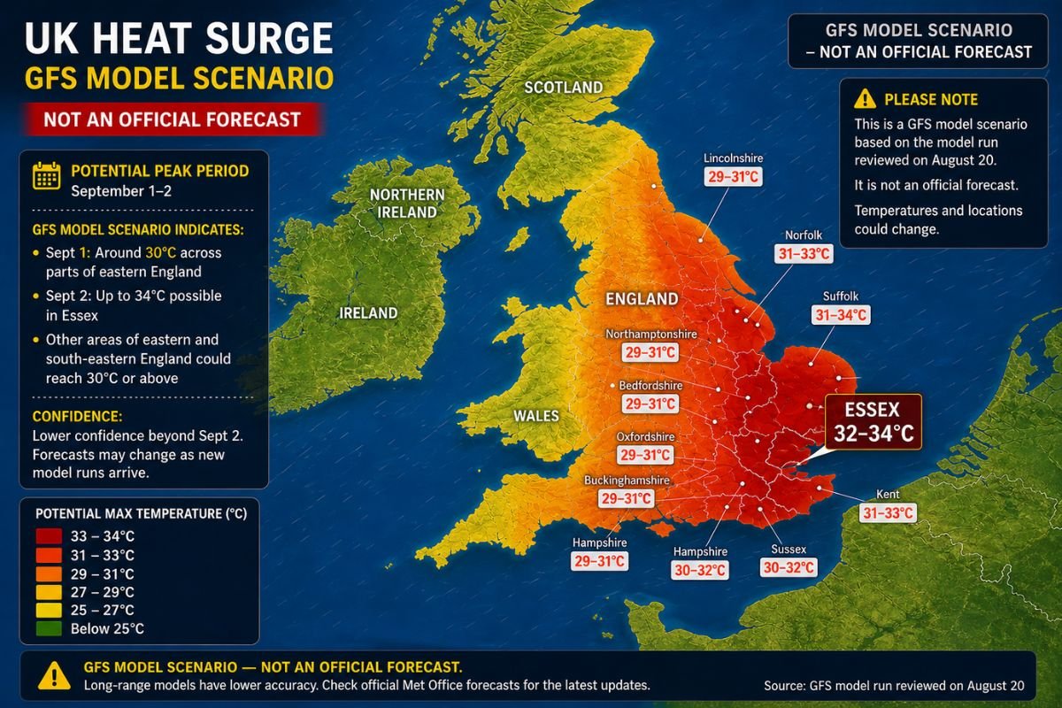
Eastern England is often particularly vulnerable to high temperatures when warm continental air moves northwards from Europe. Essex, Suffolk, Norfolk, Kent and neighbouring counties can therefore become some of the UK’s hottest locations during the right atmospheric setup.
The north and west could have a very different experience.
The Met Office currently expects a more unsettled start to September, with showers or longer spells of rain affecting parts of the UK and temperatures varying around average.
Why eastern England could heat up so quickly
The weather pattern behind the potential September heat is important.
For eastern and south-eastern England to reach the low or mid-30s, the UK would need a favourable combination of high pressure, strong sunshine and an air mass capable of bringing significant warmth northwards.
A flow from southern or south-eastern Europe can transport very warm continental air towards Britain.
Eastern England is particularly exposed to this type of setup because of its position close to continental Europe.
That does not mean every warm spell automatically produces a heatwave.
Cloud cover, wind direction, humidity, pressure patterns and the exact position of the warmest air can all determine whether temperatures reach 25°C, 30°C or something considerably higher.
That is one reason the model needs to be watched over several forecast runs rather than treated as a fixed prediction.
What does the Met Office currently say about September?
This is where the distinction between a weather-model scenario and an official long-range forecast becomes important.
The Met Office’s current long-range forecast for August 24 to September 2 says conditions are likely to be largely dry and settled early next week as high pressure extends across the country, before becoming more unsettled towards the turn of the month. It says temperatures are likely to be near average overall, although some short-lived warm and humid spells are possible, especially in the south.
For September 3–17, the Met Office currently expects a rather unsettled start to autumn, with showers and longer spells of rain mixed with drier periods. Temperatures are expected to vary around average, although warm or hot spells remain possible.
So there is currently no official confirmation of a prolonged 34°C heatwave.
Instead, there are two signals worth following:
GFS: potentially shows a sharp burst of heat around September 1–2.
Met Office: supports the possibility of short-lived warmth but currently expects a more unsettled and broadly near-average pattern into early September.
That distinction is crucial.
Would 34°C be unusual for September?
Very much so.
The UK’s September temperature record is 35.6°C, recorded at Bawtry in South Yorkshire on September 2, 1906.
That means a temperature of 34°C would come within roughly 1.6°C of the UK’s highest September temperature ever recorded.
So if Essex were to reach 34°C on September 2, it would not break the national September record, but it would still represent an exceptionally hot day for the beginning of autumn.
The date is significant too.
September marks the start of meteorological autumn, meaning average temperatures are already beginning to decline from their summer peak.
A 34°C afternoon at this stage of the year would therefore be far outside what most people would normally expect from early September.
Does 34°C automatically mean a heatwave?
Nope.
One very hot day doesn’t count as a heatwave under the UK’s official definition.
The Met Office defines a heatwave in the UK as when the highest temperature of the day is at or above the appropriate heatwave criteria for that location, for at least three days in a row.
Those thresholds vary around the UK as the climate is different in different sections of the country.
So if Essex hit 34 degrees on September 2 but then temperatures fell away significantly, that would be a very hot day but not necessarily a formal heatwave.
To be labelled a heatwave, the appropriate threshold would have to be reached or exceeded for three days consecutively.
This is an essential distinction as headlines can frequently refer to any spell of unusually hot weather as a ‘heatwave’, even if the official conditions have not been met.
Why 2026 has already been an extraordinary year for UK heat
The possibility of another September temperature spike comes after an unusually warm and record-breaking year.
In late May, the UK experienced exceptional heat for the time of year.
Kew Gardens reached 35.1°C on May 26, setting the official UK record for the highest daily maximum temperature ever recorded in May. The previous UK May record was 32.8°C.
The heat returned in June.
On June 26, 38.0°C was recorded at Lingwood in Norfolk, establishing the UK’s highest June daily maximum temperature on record. The June record was subsequently verified by the Met Office.
The significance of the summer heat was highlighted again in July.
The Met Office reported on July 29 that a temperature of 35°C or higher would represent the seventh day of 2026 on which the UK had reached that level.
Earlier in July, the Met Office also reported that 2026 had already recorded temperatures of at least 35°C in May, June and July — the first year in the UK weather record to do so.
That gives the possible September heat an important context: this would not be an isolated hot event in an otherwise cool year.
July 2026 was exceptionally dry and sunny
The temperature story is only part of what made the summer unusual.
July 2026 produced extraordinary rainfall and sunshine statistics.
The Met Office reported that England and Wales provisionally recorded their driest July on record, while southern England experienced its driest month ever recorded in a series dating back to 1836.
Southern England received just 1.9mm of rainfall during July, equivalent to around 3% of its long-term average.
The same month was also exceptionally sunny. The UK, England and Wales all recorded their sunniest Julys on record, while England and Wales experienced their sunniest calendar month ever observed.
The contrast explains why the return of rain in August has mattered so much.
After such an exceptionally dry July, rainfall is valuable even if many people would prefer another stretch of sunshine.
Could another hot spell arrive after all that rain?
Yes.
Rainfall and heat are not mutually exclusive in the UK’s weather pattern.
A period of unsettled weather can quickly be followed by high pressure and warmer air if the atmospheric circulation changes.
That is essentially what the current model signal is suggesting: a change from cooler or wetter conditions towards a possible short-lived burst of warmth at the beginning of September.
But whether that transition happens exactly as currently shown remains uncertain.
The Met Office’s current outlook itself illustrates this uncertainty, with the forecast shifting towards more unsettled conditions around the turn of the month.
What should people watch over the next two weeks?
The next several model updates will be much more useful than any single long-range run.
There are five things to watch.
1. Does the 30°C signal remain?
If repeated model runs continue showing eastern England reaching around 30°C or higher around September 1, confidence in a warm spell will increase.
2. Does the 34°C peak survive?
A 34°C forecast this far ahead can easily become 31°C, 28°C or something cooler as the atmospheric pattern changes.
The key is whether the high-temperature signal persists.
3. Do other models agree?
Confidence increases when independent forecasting models begin showing a similar pattern.
One model run should never be treated as equivalent to a consensus forecast.
4. What does the Met Office forecast closer to the date?
The Met Office’s shorter-range forecasts will become increasingly valuable as September approaches.
Its long-range forecast is deliberately broad because local detail becomes less reliable at greater lead times.
5. Does the warm spell last three days?
If temperatures stay above the relevant heatwave thresholds for at least three consecutive days, the question could shift from “Could there be a hot day?” to “Could this become an official heatwave?”
At present, that is not confirmed.
What does this mean for Essex?
Essex is one of the locations to watch most closely if the current GFS scenario continues.
The model signal currently places the county near the centre of the potential early-September warmth, with temperatures potentially approaching 34°C on September 2.
But Essex would not necessarily record the UK’s highest temperature.
Local conditions can make a significant difference, and the hottest location can shift depending on wind direction, cloud cover and the position of the warmest air.
For now, 34°C should be considered a potential model outcome rather than a local forecast.
Could September 2026 break a temperature record?
It is possible, but the current 34°C scenario would not be enough to break the UK September record of 35.6°C.
A temperature of 34°C would instead come close to that record.
To break the national September record, a location would need to exceed 35.6°C under the official observing and verification standards used by the Met Office.
That is another reason the next couple of weeks will be worth watching.
If the warm-air plume becomes stronger in later model runs, the potential could change.
If it weakens, the September heat story could disappear almost entirely.
What does the heat of 2026 indicate in the broader climatic picture?
The record heat in the UK this year also fits within a larger climate pattern.
The Met Office has already said that the 2026 heat episodes are extraordinary and studies into the May and June heatwaves concluded that human-induced climate change made the maximum temperatures of both events 3–4°C higher than they would have been.
It does not state that climate change will determine precisely when or where the next hot day will take place.
Individual incidents are still dictated by weather patterns.
But a warmer baseline temperature can make extreme heat more likely, and can make the intensity of heat events greater when the correct atmospheric pattern forms.
That bigger picture is relevant when analysing why another abnormally warm stretch in September would matter.
So, is a 34°C September heatwave coming?
Not yet confirmed.
The current GFS model scenario shows a potentially significant warm spell around September 1–2, including a possible 34°C in Essex and temperatures above 30°C across parts of eastern and south-eastern England.
The Met Office’s current long-range outlook is more cautious. It expects temperatures to be around average overall in early September, while allowing for some short-lived warm or hot spells.
Therefore, the most accurate description at this stage is:
A 34°C early-September heat surge is possible, but it is not yet a confirmed UK forecast.
The next model runs will determine whether the signal strengthens, weakens or disappears.
Frequently Asked Questions
When could the next UK heat surge happen?
The current GFS scenario points to September 1–2, 2026, with temperatures potentially reaching around 30°C on September 1 and around 34°C in Essex on September 2.
Where could temperatures be highest?
Eastern and south-eastern England are the main areas to watch, particularly Essex, Suffolk, Norfolk, Kent, Cambridgeshire, Hertfordshire and neighbouring counties.
Is 34°C officially forecast?
No. The 34°C figure comes from a long-range GFS model scenario and should not be treated as a confirmed forecast.
What does the Met Office currently expect?
The Met Office currently expects a more unsettled start to September, with temperatures generally around average, although short-lived warm or hot spells remain possible.
Would 34°C automatically be a heatwave?
No. The UK heatwave definition requires at least three consecutive days meeting or exceeding the relevant temperature threshold for the location.
What is the UK’s September temperature record?
The UK September record is 35.6°C, recorded at Bawtry, South Yorkshire, on September 2, 1906.
Has 2026 already broken UK heat records?
Yes. May produced a new UK May record of 35.1°C at Kew Gardens, while June ultimately produced a UK June record of 38.0°C at Lingwood, Norfolk.
Sources and forecast methodology
This article distinguishes between numerical weather-model output and official forecasts.
The potential 34°C temperature referenced in this article comes from the GFS model scenario available for review on August 20, 2026. Because individual model runs can change substantially at long lead times, the figure is presented as a potential outcome rather than a confirmed forecast.
Official forecast context is taken from the UK Met Office long-range forecast, which uses output from multiple weather models and deliberately provides broader guidance at longer ranges because local detail becomes less reliable with increasing forecast lead time.
Historical UK temperature and climate statistics are based on Met Office records and publications.
Forecast status: This article should be updated when new model runs materially change the September 1–2 temperature signal.
Important: Readers should use the Met Office’s latest short-range forecast and official weather warnings for decisions involving travel, health or safety.




Leave a Reply