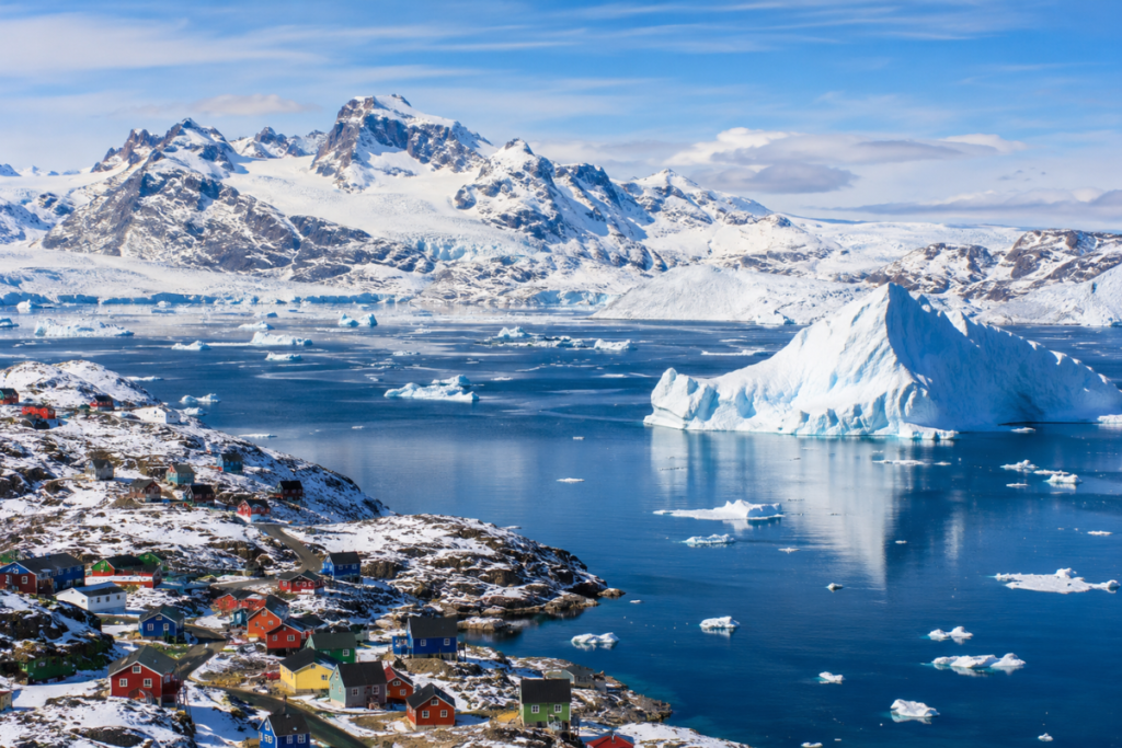
The largest island in the world is Greenland. Its total area spans about 2,166,086 square kilometres (836,330 square miles). Nestled right between the Arctic and Atlantic oceans, it’s mostly known for an astonishingly huge ice sheet, deep fjords, polar wildlife, and a rich local culture. Sure, Australia happens to be much bigger, but geographers treat it as a continent rather than an island. [1][2]
Ever wondered what holds the record for the biggest island on Earth?
The short answer is Greenland. It’s a massive Arctic landmass packed with jagged mountains, ancient glaciers, and stunning frozen vistas.
Flat wall maps tend to throw people off. Standard map projections distort sizes near the poles, so Greenland often looks way bigger than it really is.
Even though it stretches over 2.16 million square kilometres, very few people live there. Most of the terrain is buried under thick ice anyway.
We’ll dig into Greenland’s size, exact location, terrain, cold weather, and local population. Plus, we’ll explain why it gets to keep the island title while bigger landmasses don’t.
Which Is the Largest Island in the World?
Greenland stands as the world’s largest island not classified as a continent.
Official records from Statistics Greenland and UN data place its total area at roughly 2,166,086 square kilometres.
It sits northeast of mainland Canada. Waters from the Arctic Ocean and North Atlantic wash against its icy edges.
Politically speaking, it operates as an autonomous territory linked to the Kingdom of Denmark. It runs its own local government affairs internally.
Its sheer physical footprint makes it a dominant feature on Arctic maps.
The headline attraction is the Greenland Ice Sheet. It forms one of the largest continuous ice bodies anywhere on Earth.
Also Read: Who is Tess Daly’s Eldest Daughter? Meet Phoebe Elizabeth Kay
Quick Facts About Greenland
- Name: Greenland
- World ranking: Largest island
- Total area: 2,166,086 square kilometres
- Location: Arctic and North Atlantic region
- Capital: Nuuk
- Political status: Autonomous territory within Denmark
- Major feature: Greenland Ice Sheet
- Languages: Greenlandic (Kalaallisut) and Danish
- Famous for: Massive glaciers, steep fjords, and northern lights
Why Is Greenland the Largest Island in the World?
Greenland wears the crown simply because of basic geography rules. It happens to be the biggest slice of land conventionally labelled an island instead of a full continent.
Usually, an island is just land completely surrounded by water.
Continents are identified differently. Scientists use geology, tectonic plates, overall scale, and historical precedent to define them.
Oddly enough, there isn’t one single universal rule or size cut-off line separating islands from continents.
Take Australia, for instance. It covers nearly 7.69 million square kilometres, which makes it over three times larger than Greenland. Yet geographers classify Australia as a continental landmass, leaving Greenland at the top of the island leaderboard.
Where Is Greenland Located?
You’ll find Greenland way up in the Northern Hemisphere, sitting just northeast of Canada.
The chilly Arctic Ocean caps its northern edge. The North Atlantic meets it to the southeast, while the icy Davis Strait and Baffin Bay divide it from Canada.
Because of this high-latitude spot, it endures brutal winter seasons. Extreme daylight shifts occur between summer and winter.
Geographically, it rests squarely on the North American tectonic plate. However, centuries of history and political ties link it directly with Denmark and Europe.
How Big Is Greenland?
Greenland spans roughly 2.17 million square kilometres, dwarfing every other island on the planet under standard global definitions.
To put that into context, take a look at how it compares to other major world islands and landmasses:
| Landmass | Classification | Approximate Area (sq km) | Approximate Area (sq miles) |
|---|---|---|---|
| Australia | Continent | 7,692,000 | 2,969,900 |
| Greenland | Largest Island | 2,166,086 | 836,330 |
| New Guinea | 2nd Largest Island | 785,753 | 303,381 |
| Borneo | 3rd Largest Island | 748,168 | 288,869 |
| Madagascar | 4th Largest Island | 587,041 | 226,658 |
Its massive surface holds steep coastal cliffs, rocky coasts, deep fjords, and sweeping ice fields.
Over 80% of its land area stays buried beneath permanent glacier ice year-round.
That forces nearly all 56,000 residents to cluster along narrow, ice-free coastal strips.
No highways connect the scattered towns. Travelling between places means taking boats, snowmobiles, or small prop planes.
Because of its colossal ice cover, climate scientists closely watch Greenland to study global warming and sea-level trends.
Also Read: From Hear’Say To The Royal Palace: The Story Of Myleene Klass
What Is the Capital of Greenland?
Nuuk serves as Greenland’s capital city. You’ll find this small metropolis along the southwest coast.
It acts as the central point for local politics, shipping, education, and Greenlandic culture.
Around 19,500 people live in Nuuk today. That accounts for roughly one-third of the territory’s entire population.
The town sits on a relatively clear coastline right at the mouth of a massive fjord network.
Local livelihoods rely heavily on commercial fishing, government service jobs, construction, and eco-tourism.
Is Greenland Bigger Than Australia?
Nope, not at all. Australia is vastly larger than Greenland.
Australia measures about 7.69 million square kilometres, whereas Greenland sits at 2.17 million. That makes Australia roughly 3.5 times bigger.
The distinction boils down to arbitrary terms. Geographers call Australia a continent, while treating Greenland as an island.
That exact rule is why Greenland gets the top spot on island lists, even if other isolated landmasses are far bigger.
What Is Greenland Famous For?
Greenland is celebrated worldwide for its dramatic polar environment and unique features.
1. The Greenland Ice Sheet
This monumental slab of ice covers around 1.7 million square kilometres. It locks up nearly 8% of all freshwater on the surface of the planet.
2. Massive Glaciers and Icebergs
Slow-moving glaciers push ice out toward coastal fjords. Massive ice chunks regularly snap off into ocean waters, forming huge drifting icebergs.
3. Deep Fjords and Peaks
Jagged coastline canyons cut deep inland. Dark basalt mountains frame the water, creating scenic views popular with polar expedition cruises.
4. Polar Wildlife
The harsh Arctic tundra supports hardy species. You can find polar bears, muskoxen, Arctic foxes, ringed seals, and beluga whales roaming the coastlines.
5. The Northern Lights
Crisp dark skies give travellers clear views of the aurora borealis. The glowing green lights swirl over northern villages throughout the winter months.
What Is the Climate Like in Greenland?
Greenland features a harsh polar and tundra climate, though local conditions swing based on where you stand.
Inland regions remain frozen solid year-round. Sub-zero temperatures dominate the central ice cap during almost every month.
Coastal areas get somewhat milder summer weather. July temperatures in southern fjords can creep up to around 10°C (50°F).
High latitudes bring dark polar nights in winter and weeks of endless daylight during summer midnight-sun months.
Summer travellers come to hike, cruise fjords, and spot whales. Winter visitors face frigid snows to catch views of northern lights.
Global warming affects this frozen territory fast. Scientists note that the ice sheet loses over 250 billion metric tons of ice annually, driving global ocean levels higher every decade.
Frequently Asked Questions About the Largest Island in the World
1. Which is the largest island in the world?
Greenland holds the record, spanning an area of roughly 2,166,086 square kilometres.
2. What is the largest island after Greenland?
New Guinea ranks second globally, covering approximately 785,753 square kilometres.
3. Why is Australia not considered the largest island?
Australia is much bigger, but geographers classify it as its own continent rather than an island.
4. What is the total area of Greenland?
It covers about 2,166,086 square kilometres (roughly 836,330 square miles).
5. What is the capital of Greenland?
Nuuk is the capital city and houses the territory’s main government centres.
6. Is Greenland covered in ice?
Yes, indeed. An ice sheet buries roughly 80% of its landmass under thick glaciers.
7. Is Greenland a country?
It operates as a self-governing autonomous country within the broader Kingdom of Denmark.
8. Is Greenland larger than India?
No. India covers about 3.29 million square kilometres, making it distinctly larger than Greenland.
9. Which ocean is Greenland in?
It rests right between the frigid Arctic Ocean and the northern waters of the Atlantic Ocean.
10. Why is Greenland important to the world?
Its melting ice sheet directly impacts global sea levels, while its unique ecosystems help scientists study Arctic climate change trends.
Conclusion
Greenland remains the reigning champion among global islands. Spanning 2.17 million square kilometres, it holds an unbeatable geographical record.
Its sheer scale, massive glaciers, wildlife, and distinct cultural history make it a fascinating corner of our planet.
Even though Australia takes up far more room, its continental status leaves Greenland sitting comfortably at the top of the list.
For students, geography fans, or adventurous travellers, Greenland offers a great look at how Earth’s landmasses get measured, sorted, and defined.
Sources and References
1. Statistics Greenland — Greenland in Figures. Official statistical publication describing Greenland’s area and geography:
2. United Nations Statistics Division — UNData: Greenland. Country profile and surface-area data:
3. Guinness World Records — Largest Island. Explains Greenland’s ranking and the conventional exclusion of Australia:
4. Geoscience Australia — Islands. Background on the distinction between islands and continental landmasses:
Editorial note: Figures and classifications are based on the cited geographical and statistical sources. Confirm the latest population figures and official data before publication if adding time-sensitive statistics.




Leave a Reply